Tuesday, October 15, 2013

Labor Day Hike: Bear Brook State Park Beaver Pond Trail

Waaay back in September, we went on our annual Labor Day weekend camping trip. I came home and edited some photos and then life got really busy. So now that I've gone on several more hikes and have a few more posts to do, I figured I should finish this one!

We camped at Bear Brook State Park in New Hampshire. It's just outside of Manchester in Allenstown. It is the largest developed state park in New Hampshire and I definitely can see why it's a favorite for many. There were trails for biking and hiking. Water for swimming, small craft boating, and fishing. There's a museum and archery range too. And of course camping! If you look at the map of the park, we were camping down by Beaver Pond.

We chose our sites at the end of a road and clustered together. With small kids we like to be away from the main camp so we're not disturbing others and so that the kiddos can have a full night sleep. One family had to cancel last minute due to family illness so it actually ended up being only us with Lil' Dude and about 4 friends.

We really tried to relax this trip. I find it a bit more challenging as a mother to relax while camping or hiking. It seems that I worry more and stress about much of the trip. I think I'm getting better at it as each trip get's easier.
Fungi Covered Log- so peaceful!
Now for the important stuff... hiking!

Since we were down by the Beaver Pond, we decided to strike out for a small loop hike. It was a warm sunny day with big fluffy clouds in the sky. My friend offered to take Ansel so that I could take photos while Big Dude carried Lil' Dude in his pack.
Thanks Mel!
The trail was mostly flat terrain that snaked in between Spruce Pond and Beaver Pond. The water on Spruce Pond was so reflective. We all spent some time there taking photos and enjoying the views.

Spruce Pond
Spruce Pond
Photo Taking
The trail gave us plenty of opportunities to look out for water fowl and signs of beaver.
A little push might be fun.... maybe not with their cameras
Beaver Pond
Since we were close to wet land areas, it almost goes without saying that we would have board walks. They were in a bit of disrepair though so you needed to watch your step. It was neat to walk among the cattails that were taller than me. Tons of dragonflies zipped this way and that.  
Board walk
Cat Tails
Board Walk
View from Board Walk towards Beaver Pond
Some of the board walks were worse than others....
Something's missing here
The trail was fairly well traveled so there were only a few times when we worried about getting lost. The trail had several unofficial off shoots and at one point we actually did go off trail and get turned around. Fortunately, we had the map and followed the water back to the trail. 
Trail Sign at the Junction of Beaver Pond Trail and Lynx Trail
At that time, the caterpillar life was very active. I was fascinated by these cocoons where the leaves were rolled up around the caterpillar. I have yet to figure out what type of caterpillar they are.
Cocoons
A Cocoon
Soon after the trail sign we saw this lovely heron just resting in the water. I always get excited when I see them. I know that they aren't that uncommon but they make me think about when I was in the Everglades attempting to learn about different water fowl. I still am terrible at identifying birds. 
Heron
We made it safely back to the swimming beach at the campground. Just before we got there I had to take this picture of Mel's boots. These were boots that she got off of me. They were my first true pair of hiking boots from L.L. Bean. I got them when I was around 12 years old for Girl Scout camp. Teal and purple have always been a favorite color combo for me.  Well needless to say, they have seen many miles and it looks as if Mel might need to invest in a new pair.
Good bye my friends!

The trail was easy to hike though definitely bring a map and pay attention to blazes. I definitely don't  recommend it for strollers or toddlers that are free roaming (easy to fall into the water) but parents with carriers and of course the unencumbered adult will find this a breeze. 

Where: Beaver Brook Trail, Bear Brook State Park, Allenstown, New Hampshire


Directions:  From I-93:New Hampshire Exit 9N onto Route 3/28 North and follow signs to Bear Brook State Park. From I-95: Route 4 West to Route 28 South and follow signs to Bear Brook State Park.                               
Posted by Picasa

Friday, July 19, 2013

Mount Agamenticus - Little Dude's First Mountain


So on the same day that we went to the Rachel Carson Nature Preserve we decided to climb Mount Agamenticus. It was a pleasant day compared to the heat wave that was going on the days prior. We were getting ready to head for home and didn't want to shop or go to the beach so we decided to hike.

I've climbed Agamenticus several times now. It's a rather easy hike to do. You can even drive to the summit if you want to. . We loaded up the car with dog, baby carrier, Little Dude and my camera.We didn't exactly have directions but we knew there were signs for it off of Route 1 and it was a nice day for a drive. We found the auto road easily and turned up it. We parked at the first lot we noticed and grabbed a trail guide from the kiosk.


Kiosk at parking lot
The trail heads and trails were well labeled and very straightforward. We checked out the map and decided to follow the Ring Trail to Witch Hazel Trail to the Summit. We entered the woods and immediately wondered if we should have grabbed the mosquito spray. I'm sensing a pattern here. I've been a hiker for most of my life, you would think that I would be prepared. I'm not sure if you noticed but this is the THIRD hike in a row where we forgot bug spray. Fortunately, the bugs were not as bad as the morning hike. 
Ring Trail
The ring trail was a nice easy walk through the woods. Easy of course for me because I was carrying a camera and a dog lead. Big Dude had a heavier load. It was his first hike with any elevation gain carrying a baby. I had carried him the previous year in my soft carrier. And the last time Big Dude had carried a pack heavier than a day pack was when we climbed Owl's Head in 2005. He managed just fine though.
 
Ring Trail
Little Dude was looking around at everything he could see. It's so neat to see him experiencing the world like this. Hopefully, we can teach him an appreciation for nature and being outdoors. 

The trails were superbly maintained. We came to one spot where the rains had caused some erosion. Even then, it was easily navigated and tidy.

Erosion on the Ring Trail
We came to the summit by way of Witch Hazel. I do love emerging from a dark woods to the sun and lots of views.  

Nearing the summit on Witch Hazel
The trail had changed since my last hike there. They actually had cleared lots of the trees and were rerouting the trail. I had noticed regrowth areas on the ring trail as well. I'm sure this mountain is well traveled and trails need to have a rest once in a while. It was a bit confusing though. The signs were not so obvious and I didn't feel that the trails match up with the map.

Hiking to the summit on new trail
We made it to the summit and let Little Dude run free. We circled the Learning Lodge as they don't allow dogs and went up onto one of the platforms. From there we could look back towards Short and Long Sand Beaches and could even see Nubble Light House.


 We went from the high platform down to an observation tower. Little Dude loved running across the field.
First summit
 

From the double platform you could see to the west and all the way to Mount Washington.
Map of view       


While we were on the platform we noticed that storm clouds were racing in. The change in the sky was pretty obvious to us. And we decided to move along. We could see rain over NH and it was only a matter of time before it reached us.

Change of skies within a minute
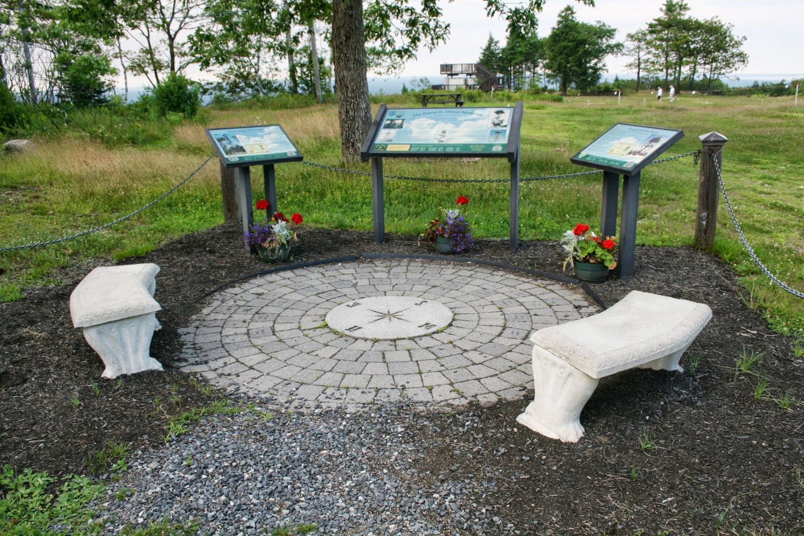
We debated about which route to take back. I'm not a huge fan of hiking the same trail back down as I came if there is a possibility to do a loop. We decided to head towards the parking lot at the summit and see what we could see. Along the way we stopped just below the fire tower to admire a memorial for David Hilton who was a fire warden, skier and historian. I forgot to mention that this used to be a ski hill. Granted, I don't usually think Southern Maine when I think skiing, especially on the coast!

David Hilton Memorial
We spotted the Blueberry Bluff trail across the parking lot and went straight for it. Big Dude seemed to be getting nervous about a storm. So we hoofed it to the trail.

Summit Parking Lot
Trail to Blueberry Bluff
Trail Sign
Views near Blueberry Bluff
We wandered down Blueberry Bluff and immediately I saw the blueberry bushes. Big Dude was in such a hurry he missed them. I snagged a few and let the Little Dude taste his first wild Maine blueberry. He didn't seem to be a big fan.

Blueberries!
We re-entered the forest and moved rather quickly down the mountain. The trail was rocky but not steep. The clouds had definitely come in and the air was changing. I decided that we need to get a longer lead for Ansel. He can't be off leash but sometimes directions that are easier for him to climb are not so easy for me.

Blueberry Bluff
Big and Little coming down carefully
As we got closer to the Ring Trail we found more trail re-routing. But again, the trails were well marked.
You can't get there from here
We got back on the ring trail and followed east. Along the way we came across book pages that were laminated and stapled to boards. We had seen them on the Witch Hazel trail as well. The animal art seems fun and I would love to learn what book this is. 

Books and hiking (two of my favorite hobbies)
We crossed the auto road and then hiked a short distance back up the mountain to our car. Just before we got back to our car we found this guy....


At this point, the mosquitoes made their reappearance. We got Little Dude in his car seat and gave the pup some water. I drove us up to the top of the auto road just so I could say we did it and then we went off to dinner.

It was an easy hike and looking at the map, I can see several ways to make it more challenging. It would be lovely for a picnic lunch to just look out over the Atlantic or New England.

Where: Mount Agamenticus, Cape Neddick, Maine

Web Infohttp://agamenticus.org/


Directions: Please note GPS is unreliable at this point in time

  • Take I-95 North into Maine. Take Exit 7, York (the last exit before the tollbooth for the Maine Turnpike). 
  • Follow signs to Route 1 North (keeping right after the exit ramp). Turn left onto Route 1 North.
  • Approximately 3.5 miles after turning onto Route 1, turn left on Mountain Road. (Across from Flo’s Hotdog Stand) 
  • Follow Mountain Road for approximately 4 miles to a stop sign after crossing the interstate. 
  • Turn right and continue on Mountain Road for approximately two and a half miles from the interstate overpass. 
  • There is a gravel parking lot on the right and a paved road leading to the summit of Mount Agamenticus. Green fence posts at the entrance say “Mount A Summit”. If the road turns to gravel, you’ve gone a hundred meters too far. 
  • Turn right and drive up to the summit or park in the gravel lot to hike up. Trail maps are available at the trailheads.


Posted by Picasa

Tuesday, July 16, 2013

Rachel Carson National Wildlife Refuge


On our last day of vacation was not beach weather in Maine, so we decided to venture up to Wells where the Rachel Carson National Wildlife Refuge is (and Congdon Donuts!). We picked up some donuts and easily found the refuge. I vaguely remembered visiting this place as a kid but I wasn't sure. I know my parents took us on many walks when we visited Maine and I was pretty sure we had stopped here.


We pulled into the parking lot and there were a few other vehicles there. As we unloaded we noticed there were a few mosquitoes buzzing us. We grabbed the camera bag, dog and baby carrier and found a map with trail guide at the trail head.

The one-mile loop has eleven checkpoints and the guide gave us information on the ecosystem and the vistas that we would see. The path was a hard packed gravel trail. We did wander by some young people who were clearly doing clean up of the trails given that they had hedge trimmers, clippers and volunteer shirts on. The path was beautiful and well maintained.


Our first stop was to view the edge of the marsh. The woods was cool and moist from the rain overnight. Quickly we realized that those few mosquitoes in the parking lot had brothers and sisters. Big Dude and I were getting eaten alive! For experienced hikers we had made the error of not bringing bug spray with us. The Little Dude was okay. Apparently the bugs liked aged humans better.


We wandered down the path through hemlocks and pines. The ground was covered in gorgeous ferns. We could catch glimpses of the marsh through the trees.


After walking briskly through the trees we emerged to see a tidal creek meandering through the marsh. It was fantastic to see how the banks had been cut up by the water. These creeks mix with fresh and salt water.


Further out were the salt pannes which we discovered were low areas in the marsh that hold the water as the tide falls. These ponds were terrific for bird watching.
   

When we found our 6th stop on the guide we paused to let Little Dude out to wander a bit and so we could scratch our bug bites. There was a nice sitting area in the sun where we snapped some family photos. The view was lovely


Through the walk, Big Dude had been narrating from the trail guide for us as we moved down the path. We realized he bugs were not going to get better so we decided the second half of the hike would be done very quickly. Essentially we would speedwalk, see the check point in the distance, he would read while walking, we would briefly stop so I could snap a photo, and move on.


The trail really was lovely. I wish that we had been prepared with bug spray. Usually we keep some in our car but we had just removed it from the week before. On the ride out Big Dude counted 30+ bites on my legs that he could see while I was driving. I was terribly itching. Little Dude had only one or two. Thank goodness.


Where: Rachel Carson National Wildlife Refuge

Web Info: http://www.fws.gov/refuge/rachel_carson/

Directions321 Port Road, Wells, Maine 04090
The refuge entrance is located on Port Road (Route 9) in Wells and just minutes from exit 19 on I-95. 

  • From exit 19, turn left onto Route 9/Route109. 
  • At stop light, turn left onto Post Road (Route 1 North).
  •  Just past the Maine Diner, turn right onto Port Road (Route 9) and follow for approximately ¾ mile
  • Turn right into the refuge entrance.


Posted by Picasa