Showing posts with label Southern New Hampshire. Show all posts

Tuesday, May 26, 2015

Summer is coming! Mount Monadnock Hike

Summer is bouncing into New England. After  a hard snowy winter, we're so glad to see high temps. I admit I am a bit nervous about the lack of rain. It is quite dry in this area and I'm thinking we'll be in drought conditions in no time. Since we've had some nicer weather, I've managed to get my boots on and complete a few hikes. I've done a few small ones that I've covered in the past and last month I hiked Mount Monadnock with my Girl Scout troop.

I'm very excited, my high school aged troop decided that they want to go backpacking this summer. I, of course, jumped on it and will be hiking with them in June. I am a bit nervous as I am still breastfeeding my baby but I'm hopeful that it will work out okay. I know other moms make it work so maybe Little and I can make it work too. 

BUT back to the real point of this, Mount Monadnock. We decided to do a "local" day hike to make sure that the girls can endure a mountain. Little did we know, it was going to be a beautiful day with tons of people at the state park.

I planned to take Little (the baby) with me and then I enlisted Big Dude to join in with Lil Dude and our friend, Dan. I figured if I could hike with Little and a day pack, hiking in June shouldn't be too much of a stretch. 

We arrived at the gate around 10:30 and waited in the line to park. The rangers were directing everyone to take the most popular routes up and down, White Dot and White Cross. I've hiked these before and have actually enjoyed other routes more but we opted to follow the recommendation.
Visitor Center
After we parked we found Dan and then the GS Troop arrived. I planned to hike with the girls and Big Dude and Dan could go at a slower pace with Lil Dude who was likely to want to hike. We started out at a decent pace and the girls chatted easily while hiking White Dot. The trail initially is a gentle incline but it quickly becomes more challenging as there is little reprieve from the incline and it becomes more steep. 

Lil Dude hiking with Big Dude and Dan
At one point I worried one of our girls would not make it. She looked rather ill. We of course were prepared for this possibility but she continued on. We had a few breaks and around 12:30 I stopped to feed Little. She was a trooper just hanging out in the baby carrier while I climbed over rocks and tree roots. This is when I ended up breaking away from the troop and could not possibly catch up. Fortunately, my Dudes and Dan caught up to me and I continued on with them.

View up to the summit from the trail

Many people complimented me for being "brave" or their "hero". I definitely appreciated that as I felt like I was dying! It was tough and very warm (for her and me!). At times, I was kicking myself for this plan especially since I had only completed some small trail hikes and neighborhood walking prior to this trip. 

Just being funny

Just before White Dot and White Cross connect, I could see one of the other troop volunteers on White Cross. She called to me and let me know where the other girls were. I let her know that I most likely would not catch up but would follow behind and keep an eye out for them. Most of them hiked up to the Summit but  she and the girl who wasn't feeling well were heading down.

White Cross/Dot Junction

We continued to hike up the mountain and I was surprised by my three year old. Lil Dude LOVED climbing the rocks. We had brought our carrier for him but he was determined to climb and climb and climb. Once we reached around 2900' he started to tire but wanted to keep going. He would get in the backpack and then would want to climb again. 


Lil Dude Climbing some steeps


When we were close to the summit, I decided to stop and wait for the boys to go up. It was too treacherous for me to ascend the rock so awkwardly balanced. I was tired and concerned that I would lose my footing. I waited and watched the other hikers. I saw one guy climbing up on crutches and two others who were hiking barefoot.

Big Dude with Little resting below the summit

The boys rejoined me a short while later. Big Dude said Lil had changed his mind and wanted to come back down. We rested a bit and then started our descent on White Cross. At this point, Lil was definitely tired. You could tell by the whining and repeated changing of his mind. Truth is it was also nap time for him at this point so Big Dude decided to carry him down.

The foursome just below the summit

The trip down was steep but not a steep as White Dot would have been to come down on. We were all tired and realized it was starting to get very late when a ranger passed us going up the trail. Not too long after that Big Dude started to feel very dizzy and we paused to figure out what needed to be done. Both of us hated to do it but we asked Dan if he would mind carrying Lil Dude for a while. He definitely was our hero! 

Mini Snow Man

After that point, the trail seemed so much longer than it should have been. We rejoiced when we rejoined the White Dot Trail. We hiked out and found the once full parking lot fairly deserted. A few people we had seen on the trail (some struggling and some not) congratulated us on finishing the hike. I was pleased that I was still standing and felt very little discomfort. I definitely am proud of Lil Dude for hiking so much of the mountain and keeping a good attitude while tired. 

Lower White Cross/Dot Junction

We stopped for pizza in Jaffrey and I got an email from the other troop volunteer, making sure I was okay with them leaving (which of course I was, I knew they had commitments back home to make). I let her know we made it down safe but much later than "book time." Book time is about 4 hours, I had estimated we could do it in 5. Truth is it was closer to 7 hours for us!

The Full Moon on our drive home

Mount Monadnock is one of the most frequently climbed mountains in the world and on the day we climbed, it felt as if half the world was on the trail with us. In a sense it was nice because people were encouraging each other. Generally, I hike to get away from people though. While the White Dot and White Cross are the most direct trails, I definitely would recommend some of the other trails if you want some reprieve from humans. Unfortunately, it is a no dogs allowed state park so our pup stayed home. I've recommended this mountain to others in the past. Its local for us (within 2 hours) and challenges many people. The state park is a fee use areas and there is a campground attached to the state park as well.

Lovely view

Where:  Mount or Grand Monadnock, Monadnock State Park, 116 Poole Road, Jaffery, New Hampshire  03452

On the Web: http://www.nhstateparks.org/explore/state-parks/monadnock-state-park.aspx

Directions: From Route 3 (Northbound): Take Route 3 north to exit 7 in New Hampshire. Follow Rte. 101A west to Rte. 101 west to Peterborough, turn left for 202 west to Jaffrey. Turn right onto 124 west and follow signs to Monadnock State Park. From I-93 (Northbound): Take 101 west to Peterborough, turn left for 202 west to Jaffrey. Turn right onto 124 west and follow signs to Monadnock State Park. From I-93 (Southbound): Take 101 west to Peterborough, turn left for 202 west to Jaffrey. Turn right onto 124 west and follow signs to Monadnock State Park. From I-95: Follow Rte. 101 west to Peterborough, turn left for 202 west to Jaffrey. Turn right onto 124 west and follow signs to Monadnock State Park. From I-91: Take Exit 28A, follow MA Rte. 10 to NH Rte. 119 east. Take Rte. 202 east to Jaffrey. Turn left onto 124 west and follow signs to Monadnock State Park.
 

Friday, June 13, 2014

Mother's Day Hike at Beaver Brook in Hollis, NH

Today was Mother's Day. A day I typically leave open on the calendar for my husband to work some magic into for me. After a huge meal at Parker's Maple Barn, we drove over to Beaver Brook in Hollis, NH. Big Dude and I had been there many times but I don't believe we have been there since the Lil' Dude was born. It's one of my favorite local hikes and I have yet to explore the entire property. The Beaver Brook Association runs school programs and seasonal programming as well as maintaining the 30 miles of trails. 
Sign post at the trailhead 
We parked at the main office where you can purchase a map for $2. We opted not to (when will we ever learn!) and followed the trails based on our memories. We should have known better as there had been changes to the main lot, including the lovely yurt you can see in the picture of the sign post.

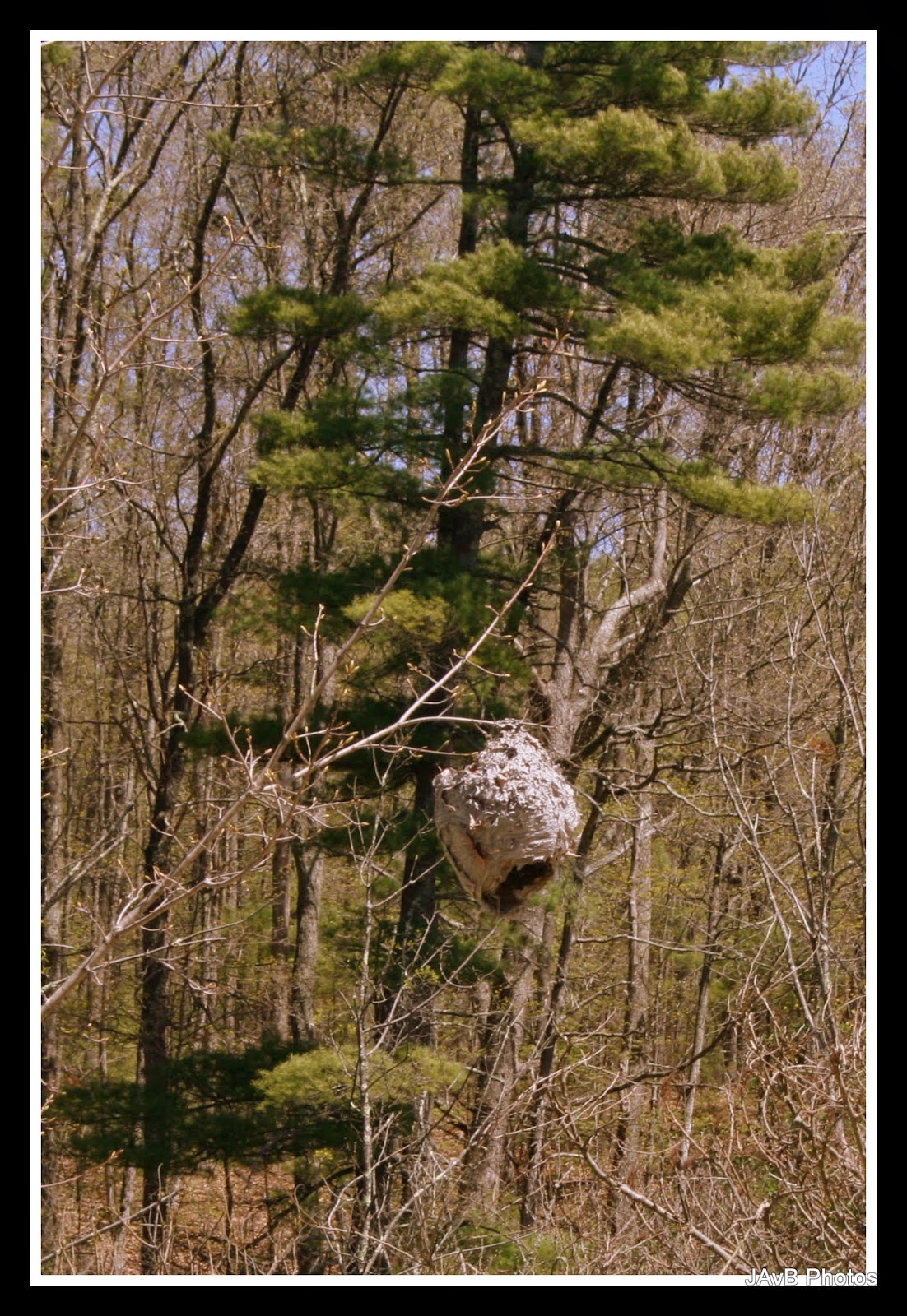
Giant Paper Wasp Nest (about the size of a basketball) near the yurt
Before we even hit the trail, we spotted this gigantic wasp nest. It was definitely inactive but I couldn't get over how big it was. It reminded me of something out of Winnie the Pooh.

Mooooooo!
We set off down Cow Lane. It's a wide, flat, hard pack path. We both remembered that it would head us down to the wetlands. The sun was shining and very warm. Lil' Dude opted to be carried in his backpack. He actually had fallen asleep in the car on the way from brunch and was still waking up.
Cow Lane
 Along the lane there was a patch of what I believe are wild violets. It had been such a long winter, I was pleased to see some of the wildflowers are starting to bl
Wild Violets
I must have been inspired by the violets. The next sign post was for the Wildflower Trail, which we of course followed. Big and Lil' Dude took off pretty quickly as I took pictures. They even missed the pretty yellow flowers I found. I really need to brush up on my flora knowledge. When I get a chance I want to match up all my flower pictures with actual names.

Wildflower Trail
 We did not see too many flowers on the Wildflower Trail, so when we found the junction of Big Tree Trail, we followed it.

Awesome Tree Id Posts
 The Big Dude had to stop at EVERY Tree Id Post and read them aloud. He does this in museums too. I doubt he remembers half of what is on them and still can't idea a Black Birch from a Paper Birch.  The Id Posts were very well constructed and had interesting information along with how to identify the trees.
Little White Flowers

Big Tree Trail

Now that I'm looking at the map, I think we walked all of the Big Tree Trail. The field was hot and sunny. Lil Dude was looking for birds the whole time but didn't find any. 

At this point Lil Dude decided he wanted to hike. Of course he did! The trail was a steep drop down and he was terrifying his poor mother the entire time. We reached a lovely marshy junction at Maple Leaf Trail. I was amazed that the bugs weren't worse.


We hiked along in the cool of the trees and spotted some unusual plants. I really liked these plants that decided to grow on top of this huge rock. 


Eventually we wandered towards some running water (really we should have brought a map). It was lovely to hear the brook. 


Lil' Dude popped in and out of wanting to be in the backpack and hiking. He did really well on the flatter areas. 


The Cow Path was lush and green. There were wildflowers on the side of the trail if you kept your eyes open. 


We arrived at this junction and opted to follow a path that we saw some other hikers coming down. It of course was a wrong turn. I realized this as I could hear the traffic on Rt. 130 getting louder and louder. So we turned back. 


Compared to the rest of Beaver Brook this trail was the least scenic, though I did get some great photos. The trail was clearly being worked on with trucks and logging operations. Here's a few pretty sights that I spotted. 

Random cairn in the water

Mossy area

We hiked up and Lil Dude managed to climb this pretty big hill. I was a bit out of shape (and 4 months pregnant) and found it to be slightly challenging.


Up a big big hill

He heard airplanes flying overhead so of course we stopped to look for them. I also found more wildflowers.


We stopped for a snack and water break. I heard some rustling in the leaves and spotted this lovely little garter snake. He politely posed for photos.  


On the other side of the hill, our littlest hiker was getting tired and cranky. After he tripped some he decided that the backpack was for him. So he was back in the carrier.  We found the bridge that crosses the top of Spatterdock Pond to Cow Lane. Lil Dude decided he wanted to cross. Bravely, Big Dude and I let him go. I pointed out the frogs and fish. 


For his first hike of the year, Lil' Dude did real well. He navigated tough terrain for a 2 year old and let us know when it was too much. 


Big Dude and I made the parental decision that he would carry the Lil' Dude back to the parking lot. There was lots of protesting but we all were rather tired at that point. Back in the carrier he went and he actually rested his head a few times on the short hike back up to the car. 


I love Beaver Brook. It's one of those areas that I often wish was a bit closer. The miles and miles of trails to explore, not to mention the programming they offer, make it a terrific place to enjoy nature. I know we'll be back there again. Hopefully sooner than later. 


Where: Beaver Brook, 117 Ridge Road, Hollis, NH 03049

On the web: http://www.beaverbrook.org/

Directions: From South on NH Route 3

Head north on NH Route 3. Take Exit 6, then turn left onto Broad Street/Route 130. Drive approximately 6 miles. Bear right at the fork and travel to the set of lights in Hollis. Turn left at the lights onto Route 122 South. Drive approximately 1 mile and turn right onto Ridge Road. The Brown Lane Barn entrance is approximately .7 miles on the right. Continue .25 miles on Ridge Road to reach the Maple Hill Farm (117 Ridge Road).