Friday, June 13, 2014

Mother's Day Hike at Beaver Brook in Hollis, NH

Today was Mother's Day. A day I typically leave open on the calendar for my husband to work some magic into for me. After a huge meal at Parker's Maple Barn, we drove over to Beaver Brook in Hollis, NH. Big Dude and I had been there many times but I don't believe we have been there since the Lil' Dude was born. It's one of my favorite local hikes and I have yet to explore the entire property. The Beaver Brook Association runs school programs and seasonal programming as well as maintaining the 30 miles of trails. 
Sign post at the trailhead 
We parked at the main office where you can purchase a map for $2. We opted not to (when will we ever learn!) and followed the trails based on our memories. We should have known better as there had been changes to the main lot, including the lovely yurt you can see in the picture of the sign post.
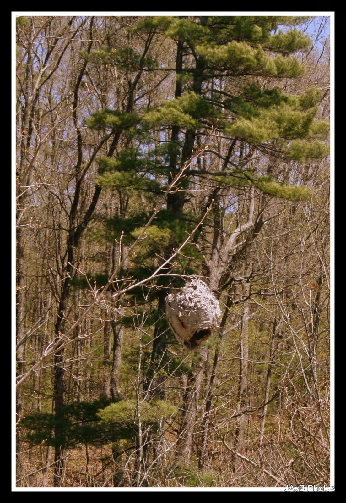
Giant Paper Wasp Nest (about the size of a basketball) near the yurt
Before we even hit the trail, we spotted this gigantic wasp nest. It was definitely inactive but I couldn't get over how big it was. It reminded me of something out of Winnie the Pooh.

Mooooooo!
We set off down Cow Lane. It's a wide, flat, hard pack path. We both remembered that it would head us down to the wetlands. The sun was shining and very warm. Lil' Dude opted to be carried in his backpack. He actually had fallen asleep in the car on the way from brunch and was still waking up.
Cow Lane
 Along the lane there was a patch of what I believe are wild violets. It had been such a long winter, I was pleased to see some of the wildflowers are starting to bl
Wild Violets
I must have been inspired by the violets. The next sign post was for the Wildflower Trail, which we of course followed. Big and Lil' Dude took off pretty quickly as I took pictures. They even missed the pretty yellow flowers I found. I really need to brush up on my flora knowledge. When I get a chance I want to match up all my flower pictures with actual names.

Wildflower Trail
 We did not see too many flowers on the Wildflower Trail, so when we found the junction of Big Tree Trail, we followed it.

Awesome Tree Id Posts
 The Big Dude had to stop at EVERY Tree Id Post and read them aloud. He does this in museums too. I doubt he remembers half of what is on them and still can't idea a Black Birch from a Paper Birch.  The Id Posts were very well constructed and had interesting information along with how to identify the trees.
Little White Flowers

Big Tree Trail

Now that I'm looking at the map, I think we walked all of the Big Tree Trail. The field was hot and sunny. Lil Dude was looking for birds the whole time but didn't find any. 

At this point Lil Dude decided he wanted to hike. Of course he did! The trail was a steep drop down and he was terrifying his poor mother the entire time. We reached a lovely marshy junction at Maple Leaf Trail. I was amazed that the bugs weren't worse.


We hiked along in the cool of the trees and spotted some unusual plants. I really liked these plants that decided to grow on top of this huge rock. 


Eventually we wandered towards some running water (really we should have brought a map). It was lovely to hear the brook. 


Lil' Dude popped in and out of wanting to be in the backpack and hiking. He did really well on the flatter areas. 


The Cow Path was lush and green. There were wildflowers on the side of the trail if you kept your eyes open. 


We arrived at this junction and opted to follow a path that we saw some other hikers coming down. It of course was a wrong turn. I realized this as I could hear the traffic on Rt. 130 getting louder and louder. So we turned back. 


Compared to the rest of Beaver Brook this trail was the least scenic, though I did get some great photos. The trail was clearly being worked on with trucks and logging operations. Here's a few pretty sights that I spotted. 

Random cairn in the water

Mossy area

We hiked up and Lil Dude managed to climb this pretty big hill. I was a bit out of shape (and 4 months pregnant) and found it to be slightly challenging.


Up a big big hill

He heard airplanes flying overhead so of course we stopped to look for them. I also found more wildflowers.


We stopped for a snack and water break. I heard some rustling in the leaves and spotted this lovely little garter snake. He politely posed for photos.  


On the other side of the hill, our littlest hiker was getting tired and cranky. After he tripped some he decided that the backpack was for him. So he was back in the carrier.  We found the bridge that crosses the top of Spatterdock Pond to Cow Lane. Lil Dude decided he wanted to cross. Bravely, Big Dude and I let him go. I pointed out the frogs and fish. 


For his first hike of the year, Lil' Dude did real well. He navigated tough terrain for a 2 year old and let us know when it was too much. 


Big Dude and I made the parental decision that he would carry the Lil' Dude back to the parking lot. There was lots of protesting but we all were rather tired at that point. Back in the carrier he went and he actually rested his head a few times on the short hike back up to the car. 


I love Beaver Brook. It's one of those areas that I often wish was a bit closer. The miles and miles of trails to explore, not to mention the programming they offer, make it a terrific place to enjoy nature. I know we'll be back there again. Hopefully sooner than later. 


Where: Beaver Brook, 117 Ridge Road, Hollis, NH 03049

On the web: http://www.beaverbrook.org/

Directions: From South on NH Route 3

Head north on NH Route 3. Take Exit 6, then turn left onto Broad Street/Route 130. Drive approximately 6 miles. Bear right at the fork and travel to the set of lights in Hollis. Turn left at the lights onto Route 122 South. Drive approximately 1 mile and turn right onto Ridge Road. The Brown Lane Barn entrance is approximately .7 miles on the right. Continue .25 miles on Ridge Road to reach the Maple Hill Farm (117 Ridge Road).


Sunday, January 26, 2014

Leaf Peeping at Vermont's Little Grand Canyon

I've been having some issues with Picasa lately and this post is long over due. Hopefully, Google will fix the problem and I can post a bit more this year. Last fall, the Dudes and I went up to Vermont for a weekend away. We stayed at a lovely resort and day tripped out to local sites. It was rainy most of the weekend but there was one cloudy/misty/drizzly day so we went over to Quechee Gorge (so fun to say!).

One of those new QR codes
Quechee Gorge is a lovely gorge carved by the Ottauquechee River after the ice age. It is 165 feet deep and over a mile in length. It is a major attraction in Quechee, VT and is part of the Vermont State Park system. We pulled up and noticed that there was a new visitors' center.

Visitors' Center

There were quite a few people about as it was prime leaf peeping time. We gathered up the Lil' Dude from the back of the car and loaded up to cross to the Visitors' Center. Inside we used the restrooms, chatted with the center volunteers, and gathered maps and brochures for local things to do. Then we went out the back door to the trails. 

Most people start the hike down the gorge over by the bridge and in the past that is where I have hiked. However, the new center brought new trails. After a quick stop to adjust the kid carrier we entered the woods.

View from the trail

The woods were damp and smelled lovely. I like that earthy post-rain smell. Occasionally, there would be the cotton candy smell of decaying foliage. The trail had some step portions but for the most part it was an easy grade to the main trail. 

Warning Warning!

The main trail pretty much is a straight path down hill. We found all the people there. Some in flip flops and high heels. Some in crazy club appropriate get ups. Others with sensible shoes and warm cloths. It was pretty good people watching. 

Side Trail?

We passed a trail that went to the state park campground and then a new "trail" that wandered into the woods. I'm not sure if it really was a trail as it's not on the maps and not blazed. Perhaps it was for some wood clearing.

Quickly we found the bottom of the gorge and carefully went out on the rocks. The view was lovely but the overcast weather downplayed the brightness of the foliage. At the edge of the rocks we could see the bridge for Route 4. 


Looking up stream to Rt. 4

We watched a family with teenage children get soaking wet. I'm fairly certain I heard the mother tell the kids not to go in the water with their shoes on. But the older son did. The girl took off her shoes. Wonder if he had blisters. I would not want to be in the water. It was definitely cold!

Water in the rocks


View up to the bridge

We chatted with another photographer and his girlfriend. Like us, he had not been there in a few years. We remarked on the changes in the area. 

View downstream

We spent enough time taking photos and decided to venture uphill. On our way up we noticed a mother and son looking up at a tree. I dropped back and quickly spotted what they saw.  

Woodpecker

A small woodpecker was making quite a bit of noise. I managed to get a quick picture of it before it wandered up the tree. He was moving pretty quickly. A bunch of city tourists (totally stereotyping here) paused to see what we were looking at. They were unimpressed. 

Fence along the trail
Big Dude grumbled some at the wiggly load on his back. After we got far enough up the trail we let the Lil' Dude out to hike. He was so proud of himself as he went up the big hill.


Big and Lil' (my favorite picture)


He only wanted to go to Big... this picture is a lie


Romping in the leaves

Lil' Dude quickly tired and we needed to carry him. He greatly protested being back in the carrier. We made it to the top where the bridge crossed the gorge. 

trail map


Bridge Plaque

We crossed the bridge to take some photos.

View upstream from the bridge


View downstream

While on the bridge we met a man who was looking down forlornly. He lost his mono-pod over the edge of the bridge into the water below. On the bright side he said he didn't need to worry about bringing it on his flight home. 

When we were done looking around we spent time at the Quechee Gorge Village. It's an interesting mix of shops. We sampled wine, cheese, vodka and had lunch at a dinner. We went to a toy museum and checked out the antiques for sale in the yard. Of course we had to ride the small train that ran around the property.

One day I think I would like to camp there when Lil' Dude is bigger. There are quite a few trails and fun things to do in the area. Quechee Gorge is definitely a nice (but touristy) place to visit. I'm sure we'll be back.


Where:

Quechee Gorge is located along the Ottauquechee River in the western part of the town of Hartford. U.S. Route 4 passes through, just south of the village center, connecting with Woodstock and Rutland to the west and with White River Junction to the east.

Website:


Quechee State Park


Driving Directions: 

From Jct. I-89 and U.S. 4 (Exit 1): Go 3 mi. W on U.S. 4.


Tuesday, January 7, 2014

Cross Country Skiing at Great Brook Ski Touring Center

The last few weeks we've seen a fair amount of snow in Massachusetts. With the cold weather temperatures the snow has actually stuck around for more than a few days before melting and becoming somewhat icy. So my good friend Jenny and I struck out for some early Sunday morning cross country skiing at Great Brook Ski Touring Center. I know this isn't a hiking post but it seems that I only get the chance to do some cross country skiing about once a winter. Its actually kind of sad because I really do enjoy it. I only have a few friends that also cross country ski and the winters have been rather spotty lately with snow.

You've seen previous posts from me regarding hiking at Great Brook (and getting ice cream). In the winter there is a lodge/barn close to the road where the ski operations run out of. In the past, I've shown up mid afternoon or for their mid week lantern skiing. This time we arrived as they just opened up their doors. Unfortunately, one of my boots broke on a previous trip and I needed to rent ski equipment. Rentals fortunately were not all that expensive and being one of the first in line it was a quick job to do. We geared up and hit the trails immediately deciding to cross the road and get as far from the lodge as possible.

The trails are all machine groomed and with the fresh snow they were looking lovely. We followed the Maple Ridge trail down to Pine Point Loop. We quickly realized that they had added new trails since the last time we skied Great Brook. In fact, the map we got at the lodge didn't include all of the new trails. The new map is on their website though with the added trails.

 We followed the Pine Point Loop counterclockwise and followed a few short detours. The trail is fairly flat and easy to warm up on. We went out on the Beaver trail and found that the picnic table had been removed. Typically this is where we would have a snack and watch for wild life. We stood and had snacks quietly and observed the light coming through the trees.
Our old picnic spot is missing its table
Beaver trail snack stop
From there we continued around the Pine Point Loop and crossed the bridge that goes over the outlet for Meadow Pond. We had decided not to cross the street and pursue the more challenging trails. Our last trip on the difficult trails involved an injury and a hospital adventure. Since neither of us had been skiing in a while, we were wise and recognized that we weren't up for the challenge. 
Outlet for Meadow Pond
Meadow Pond from the bridge

Continuing up Pine Point Loop
We completed the loop and decided to head over to the corn fields behind the ice cream stand. As we crossed the road we could see a lovely horse grazing near the fence. He was quite content to pose for pictures.  
Pretty Horse
 We followed the Litchfield Loop and discovered a new trail off the side which included a huge hill. We watched several people tumble down it and decided to turn back towards some more basic trails. We continued on the Litchfield Loop and found the High Meadow Trail. On that trail we could hear a woodpecker tapping away. Jenny spotted him quickly and was able to point him out. He was a little guy just enjoying the sun and an old dead tree. 
Litchfield Loop
The High Meadow trail looped back onto the Lantern Loop and we set off back towards the ski center. As we approached we could tell that more and more people were showing up. The trails were becoming quite crowded. When we arrived at the beginning of our morning the lines were minimal. As I went in to return my rentals, the line was at the door and heading out. It was a lovely day for a ski but I'm glad we made the choice to go early and I plan to do so from now on.   
Ski Center Lodge

Where:  


Great Brook Ski Touring Center, 1018 Lowell Street, Carlisle, MA1018 Lowell Street, Carlisle, MA 01741

Directions:

  • From Rte. 128 (I-95) take Exit 31B.  Follow Rte. 225 west for 7 miles to the Carlisle center rotary, then turn right on Lowell St. (following the sign to Chelmsford).  The ski touring center is 2 miles ahead on the right.
  • From Rte. 2 exit at signs for Concord center and continue to the downtown rotary.  At the Colonial Inn, take Lowell Rd. north for 5 miles to Carlisle center.  (Lowell Rd. in Concord becomes Concord St. in Carlisle.)  At the Carlisle center rotary, turn left on Lowell St. (following the sign to Chelmsford).  The ski touring center is 2 miles ahead on the right.
  • From I-495 southbound take Exit 34.  Follow Rte. 110 west for 0.6 miles to Chelmsford center, continue on Rte. 4 south for 1 mile, then fork right on Concord Rd.  The ski touring center is 2 miles ahead on the left.
  • From I-495 northbound take Exit 33.  Follow Rte. 4 south for 1.5 miles (passing through Chelmsford center), then fork right on Concord Rd.  The ski touring center is 2 miles ahead on the left.


w