Monday, May 7, 2012

Foss Farm - Carlisle, MA

Our first hike with the Little Dude was to be in the Lincoln Conservation area. However, after struggling to find the entrance we ended up at Foss Farm in Carlisle, MA. We found it by accident while we were heading to Great Brook Farm and decided to stop in. Foss Farm is a 57-acre parcel purchased in 1971 for conservation and recreation purposes. It is located on Route 225 in Carlisle, about a quarter mile west of the Concord River, on the right. It is separated from Carlisle's Greenough Land Conservation Area by a portion of the Great Meadows National Wildlife Refuge. There are many trails that seem to wind throughout the woods and past the community gardens.  

We pulled into the parking lot and unloaded our dog and our baby stroller.  The area seemed level enough to use the stroller as opposed to carrying the Little Dude.  We went off towards the sign post hoping to see a map.  Unfortunately there wasn't one (this always makes me a bit nervous) but there were many postings on picking up after your dog.  A map of the trails can be found on the conservation website.

We went off down the trail and passed a horse rider working with her horse and another pair of hikers.  We crossed a dirt road that gave the gardeners access to the gardens.  On such a nice day there were many people working on the gardens.  According to one website there are over 70 garden plots for members to tend to.  

We wandered along and into the woods.  The trails were sandy and clear of tree limbs or storm damage.  That day wasn't as buggy as it could have been given the rainy weather we had the week before.  We then came across a dirt road with a sign asking us to watch for sled dogs.  We followed the trail towards the tower and down towards the wetlands.  

We found the entrance to the Great Meadows Refuge which we didn't enter because we had the dog.  And then we found a lovely house with sheep and goats in the yard.  We could hear in the distance someone working with a whistle to train a dog.  At this point we wondered if we were trespassing and decided to turn around and head back.  We took a few side trails that meandered back up to the parking lot.  There was quite a bit of still water at the sides of the trails.  We could see the mosquito eggs waiting to hatch.  As pretty as that was we were itching just thinking about it.

When we arrived back at the parking lot, there was only one other vehicle there.  We had hiked a little over an hour.  As we looked at our dog we could see ticks all over his paws.  We put the Little Dude in the car and then tended to the dog.  We must have pulled off 30 ticks in the parking lot, another 10 when we stopped for ice cream at Kimball Farm, and then brushed out more when we returned home.  We had read in the papers that it would be a bad tick season.  It appears that they were right.  

This was a good easy stroll in the woods.  Just right for a quick outing that can easily end in an ice cream sundae or frappe.  

Monday, April 30, 2012

Baby Steps

This winter the hubby and I were blessed to have the Little Dude join our family.  While HE won't be doing any hiking until he starts walking, the two grown ups in our family plan to expose him to the outdoors as much as we can.  We're starting with short hikes at forests close to home for now.  There are tons of places near us that are just crying out for exploration.

Over the winter a friend suggested that I check out a free app for my smartphone called AllTrails.  Since I'm  assuming you are reading this on something larger than a phone, feel free to head to their website...AllTrails.com.

The app uses your phone's GPS to locate trails and paths in your immediate area based on you're activity interest.  You can rate the trails, find them on a Google map, see the trail's topo map, and write a review yourself.  I have yet to find a way to add other trails to the system via my phone.  On the website, you can connect with other hikers.

I look forward to using this to find new trails to follow.


Monday, September 12, 2011

3 is a Magic Number

So once again, it's been a slow hiking season for me and The Hubs.  After we completed the Midstate Trail, I immediately purchased the Wapack Trail Guide.  I made plans and put them on my calendar.  Then I became very very very very very tired.  What I didn't know then is that my body needed quite a bit of rest to prepare for a new family member.  So all those hiking plans for July and August never happened.  The Hubs and I are very excited to be welcoming a baby.  Now that I've finished the first trimester I seem to have a lot more energy.  I hope that I can get out and do some small hikes this fall.

The subject matter of this blog will change a bit.  I can see it perhaps evolving from it's Peakbaggin' beginnings towards my geocaching explorations and some family friendly hiking and an occasional high peak tossed in.  For a long time, I have been fascinated with all the local trails out there.  My home town has a few that might need highlighting.  So with our baby news comes a new focus on playing outdoors.

Thursday, August 25, 2011

Flag to fly over all 48 of NH's 4,000-footers as tribute to memory of 9/11 victims | New Hampshire NEWS10

It's been 10 years since the terrorist planes crashed into the World Trade Center Towers, the Pentagon, and the flight that went down in Pennsylvania. For some reason, I can't believe that it's been a decade. That was about the same time I started tracking my hiking and seriously began Peakbagging. The following article in the Union Leader, reminded me about how the hiking community comes together on that day to honor that date. Here's the link to the article:

Flag to fly over all 48 of NH's 4,000-footers as tribute to memory of 9/11 victims | New Hampshire NEWS10

It's been true that I've not been hiking much since July. Unfortunately, I won't be able to hike in this event. One day in the future I would like to participate in Flags On The 48. If you are able to participate please register at Flags on the 48's webpage.

Tuesday, July 5, 2011

Midstate Trail- End of the trail or is it the beginning?

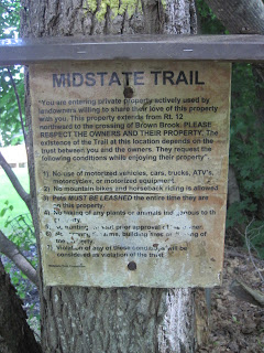
On Saturday, we set off on the final segment of the Midstate Trail.  Three off us planned to hike the final 7.72 miles to the northern terminus.  We met up at the Mount Watatic parking lot and left one car and drove down to Rt. 12.  Ben checked to see if his snake friend from the week before was there but the snake had moved on.  We set off down the road a piece until we noticed that they yellow triangles disappeared.  Fortunately, we hadn't gone too far as we found this sign tucked back in the woods next to a yard and pointing us towards the trail.  
 

I must say it is super generous of the private land owners to allow hikers to hike on their property.  I don't think I saw once instance of a hiker abusing the trail on private property (on public trails that's a different story).  I hope that these properties continue to be owned by people who enjoy nature and spending time in the woods.


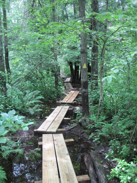
 We spent some time in this path, mainly because there was quite a bit of water running through it.  Some of the step stones were covered and we had to work our way gingerly through the streams. 

We crossed Russell Hill Road and started the climb up to Mount Hunger.  It was steep but had "flat" portions in between each ascent.  We gained about 350 feet of elevation in a little over a mile.  

We stopped for a snack on Mount Hunger because it seemed the thing to do.  There was a lovely vista north.  We could see our destination just beyond Stodge Meadow Pond.  Eventually we would climb down from our view point and walk along the shores of Winnekeag Lake (not shown).


When we did reach Winnekeag Lake, we were feeling pretty warm and were tempted to jump in.  We followed the road Camp Winnekeag parking lot and started our hike through the camp.  On the way we saw this shelter. 

 
A little further down was a fire circle with an amphitheater.  It looked like a fun place to be!  I have to admit, I miss camp during the summer.     

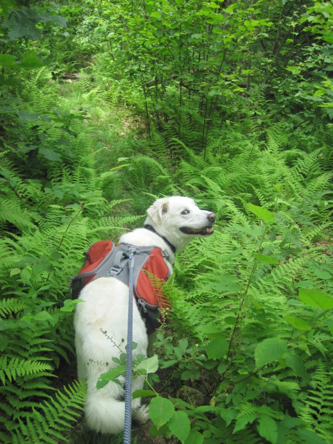
 The trails were hot and sticky.  At times the overgrowth was covering the trail.  I, unfortunately, wore shorts that day and managed to cut my legs on several raspberry bushes and pick up a few of my enemies, ticks.  We emerged from the brush and walked through a forest filled with ferns.  This of course led to comments about bears and velociraptors hiding in the woods, waiting to pounce. 


We saw neither bear or velociraptor but we did find Pierce Road and an older couple that let their GPS get them lost.  We tried to help them but the road they were looking for wasn't on my map.  They ended up turning around and heading back to Rt. 119.  We crossed 119 cautiously as the traffic was flying by and entered the Watatic Parking area.  We started up the trail and saw lots of families coming down.  We were told there were lots of blueberries up top.  Of course, many of these hikers thought we were just starting out, even though we had already hiked about 6 miles or so.    

The hike up wasn't too bad.  We did stop a few times to catch our breath but I just wanted to push on as I knew we were close to our goal.  I took a quick self portrait while waiting for my hiking buddies to catch up just before reaching the summit.  And I found this sign post which made me think of a smilie face.   


Finally we reached the summit!  Really it WAS an easy hike up but we were hot and tired.  There were lots of people up there and on the knoll to the east.  We stayed for a bit and took a few pictures.  I should have taken more but I was itchin' to find the end of the trail.  

 We found the trail that pointed towards the Wapack trail and NH and quickly went down the path towards Nutting Hill.  The trail probably wasn't as long as it seemed but its like when you know you want to go somewhere but you don't know exactly where it is, sometimes the journey seems a lot longer.  We crossed Nutting Hill and met up with a small group of hikers.  Then we went off down the old jeep road.  The trail signs were a bit confusing and we were pretty close to giving up when we found a small side trail with blue blazes.  I'm glad I brought my trail guide that day.  I almost left it in the car since I had a topo with me.  We followed the Blue Blazes and found the original Terminus Monument. 

After quickly snapping a photo because the bugs were thick, we started back south towards the fork in the trail.  We found a tiny garter snake getting some water.  
  
 When we reached the fork wit the crazy trail signs we took the path back towards Rt. 119 (State Line Trail).  It was significanly quieter than the main trail and a gentler grade for my knees.  The day was very clear and when we walked past the small pool near the parking lot the reflection of the sky and trees was lovely.   


So I started hiking this trail March 2008.  Obviously, this past year, I was determined to complete the trail.  I enjoyed the Northern Half more than the Southern Half.  I found that the road hiking in the south was uncomfortable and hard on the legs.  And of course I would prefer to be in the woods than in the neighborhoods.  
I am extremely grateful to have found this trail though.  I feel as if I have developed a better understanding about the state I live in.  Usually I hike in the White Mountains for a day hike or overnight.  This trail gave me an appreciation for neighborhood trails and local conservation groups.  I hope that it is a trail that can remain and not be overtaken by the nearby developments.  After all, we need a little bit of space to get back to reality. 

What's next?  Hmmm well the Wapack doesn't look too challenging (or is that just challenging enough?).  There's a few 4000' mountains calling my name too.  Guess I'll have to make sure to use my summer off wisely!


Posted by Picasa

Monday, June 27, 2011

Midstate Trail Part 9- Graffiti Bridge to Route 12 in Ashburnham

We started off our next section of the Midstate on a lovely sunny Sunday.  I had decided to cut the "last section" in a short piece and a longer piece so that we weren't hiking a 15-mile hike with elevation change as our finale.  It worked out very well.  We met Mel at the side of Jewell Hill Road in Ashburnham.  While waiting for her on the memorial triangle our dog found this lovely creature.
 
As you can tell Mr. Water Snake was not too pleased that Ansel The Inquisitive Dog wanted to be his friend.  I took the dog to the other side of the island and Ben took pictures and pretty much harassed it.  Mel arrrived and we drove down to Graffiti Bridge.  We went behind the jersey barriers and over towards Bragg Hill Road and South Ashburnham Road.  Then we found the entrance into the field and power lines.  I took this picture of the rusted farm equipment.  I really like how it came out.    

 
We crossed the pasture and went down into the woods.  It was quite damp from the rain the 3 days before.  But the trails were manageable enough and our feet stayed dry.  Well us 2-footed creatures stayed dry. 

This was the first time we took our dog on the Midstate.  I checked to make sure we could bring him on this segment.  Some sections don't allow dogs or are on private property and I would worry about it even if it was okay.  I noticed he was getting rather hot though so we took a break right at the sign for the Westminster Conservation Commission.   

Ansel wasn't really interested in water or a snack so we humans ate ours and then went on.  This was a very nice area to hike it.  It was well maintained and the forest was lush and green.  It is so nice to be on trails that are not littered or packed with people.  


As we rounded the corner to head up the hill to Muddy Pond Shelter, Ben spotted this guy in the middle of the trail.  Another Water Snake.  I only know this now because I compared our photos to the ones online.  I'm not afraid of snakes when I know what they are.  On this hike, I managed to come across an unknown snake in two different areas.  Ansel never saw this one.  Ben and Mel had no fear.  I managed to be quite nervous but I made it by.  I definitely advise having a camera with a decent zoom to take photos for flora and fauna identification later.  And keeping a safe distance.  I know now that I was overly cautious with this guy but I'm okay with that.  
We reached the Muddy Pond Shelter in Westminster.  It was a lovely spot for camping!  I totally want to go back.  The amount of beer cans littered about was sad but the shelter is situated in a rather clear area over looking the pond.  While we were there a family came out with fishing gear for an afternoon of fun.  I think they had the right idea!   

We moved on and then the trail became a bit of a bear.  There was LOTS of overgrowth.  The vegetation has just flourished with all the rain and sun.  Here's Ansel heading into the ferns.    

We managed to get through the brush carefully.  Some of the vines had huge prickers on them!  But I think we only had one or two scratches.  Then we found the cart road the trail cleared out again.  While in the woods we started hearing some strange noises.  As I moved into the woods and took this picture of the abandoned truck I realized that the "dog" was actually a rooster.  Even though the truck is a sure sign, the rooster confirmed that we were getting close to the main roads again.

 
Directly after we passed the truck we had to gingerly get our way past the stream that was in the midst of the trail.  Ansel of course went right down the middle. 

I found a hollowed out tree that was playing with the light.  I love taking photos through the frame of nature.  

We could tell that we were heading down hill towards Rt. 12.  The sounds of cars and a lawnmower were getting louder and louder.  When we reached Philip's Brook I took a quick picture of Ansel the Muddy Dog and of Philip's Brook from the bridge.  The water was moving downstream very quickly.  


We made it back to our car and our first snake (yes, he was still there) in about 2 and a half hours.  That seems to be about right for us.  So we finished at mile 7.72 from the north terminus.  The FINAL trip has been scheduled.  Even though this was a shorter day for us, I know we're going to appreciate it next time.  I just hope that my photos continue to get better.  I really like the shots I took on Part 9.


Posted by Picasa

Wednesday, June 22, 2011

Midstate Trail Part 8 - Wachusett to Grafitti Bridge

So I started this post right after the hike but a week has gone by and it's now time to finish. On June 11 Ben and I decided to hike the next section of the Midstate. Little did we know that the showers predicted for that day were to be more like heavy rains.

Through the beginning of the hike, I kept checking with him to see if he wanted to bail. I wouldn't say I wanted to head for home but if he did I was right on board. Alas, neither of us wanted to wimp out so we trudged on. I complain but it wasn't too bad. The rain kept the bugs at bay for most of the trip.

About 2 miles in we came to Redemption Rock. We climbed up it and looked for the engraving. The engraving was quite worn down and barely readable but it was there. 


It was here in April of 1676 that King Philip’s War hostage Mary White Rowlandson was released from Indian captivity.  You can find out more about this park by going to the Trustees of the Reservation website.

We crossed Highway 140 and entered Leominster State Forest. The rain became increasingly worse and unfortunately, we were starting to get cold. We pushed on and the rain started to let up. Fortunately, we were up on the top of Crow Hills and there was a breeze. This helped us to dry off some of our rain gear. The hills in this park had stone stairways that were quite slippery. We had to use extra caution when climbing them.

 
We traveled to the end of the park and behind new housing developments. There was a brief moment of confusion as we came to the junction of Stone Hill Road and Narrows Road. A new house had been built and the trail marker was up the driveway. We felt as if we were trespassing briefly but then we crossed back into the woods and followed the trail to the Wachusett Village Inn.  
We crossed over Rt. 2 on the Waterman Memorial Bridge. The rain had decidedly stopped (for the moment) and we stood briefly over the traffic to let the breeze dry out our raincoats. Both of our coats were wet inside and out.

East Bound


West Bound
About a mile after Rt. 2, we crossed Highway 2A. A little bit later we heard people hiking behind us. For the first time that day, there was another couple on the trail. As we worked our way to the power lines we lost the trail. They blazed through and found it again. We leapfrogged each other on the trail. They pulled ahead as we entered the pasture lands.   
Throughout this hike we've followed and crossed over many stone walls. This was the first time we actually walked on the walls. The grasses were quite high in the pasture and the trail markers were directly next to the walls so it seemed to be the most practical thing to do. 
  
We hiked along the walls in the woods after we left the pastures. The trails in this section were a tad confusing. The other couple lost the trail and we could see why. For some reason the trail started to switchback downhill and then over to the gravel Syd Smith Road. It seemed like we could have gone straight to the road and downhill.

We walked on through the woods and started seeing signs along the border of private property. At this point, I was pretty done with hiking for the day and starting to feel miserable. Fortunately, there was a boardwalk and we could hear construction vehicles. Ben thought we were near the end. Turns out he was right. We found Graffiti Bridge and our car.

I must admit, I feel that the bridge is a bit trashy. I understand that it is a tradition in Westminster for students to put their mark on it. However, the amount of rubbish that was on the ground under the bridge was awful. If only people would clean up after themselves. Oh and create better artwork.

 
At this point, we are 13.5 miles from the north end of the Midstate Trail. Our next hike is on the calendar. It seems as though our hiking buddies have found other summer fun, but that's okay. We miss them on the trail but we're determined to finish hiking this in 2011! And then back up north for the real mountains. :-) 

Posted by Picasa